13 October 2020
for Madrid Nuevo Norte

Urban regeneration, i.e. the initiative to recover brownfield sites within the consolidated city, is today a prevailing trend in international urban development. A primary focus of this urban trend is to create more friendly and liveable environments for the citizen, without extending the limits of the cities. One of the resources used to achieve this purpose is linear parks built over currently underused spaces and routes in urban centres.
Cities across the world have created dozens of linear parks on brownfield sites that had previously been occupied by railway tracks or quays. Although these infrastructures acted as a barrier between neighbourhoods, they also have tremendous potential as new parks for walking or cycling.
The factors involved in these green area projects are varied since no two cities are the same. However, despite their diversity, most linear parks have a few things in common; namely, their ability to (1) connect previously separated neighbourhoods, (2) structure the city and create a backbone for pedestrians and cyclists, and (3) create green spaces in the heart of the areas to be developed.
Linear parks are nothing new. Since the 19th century, several European cities have built boulevards over the old walls that surrounded its urban perimeters. This is the case of boulevards in Paris, Vienna’s Ringstrasse and, even, the now-extinct historic boulevards that ringed the heart of Madrid.
Although linear parks have existed for over a century, cities across the world have experienced an overall decline in the quality of pedestrian spaces since the 1950s, with cars becoming ever more prevalent in the urban centres.
Fortunately, that trend has been reversed in recent years, and the presence of pedestrians in cities has again gained prominence.
Spain boasts excellent linear parks that have noticeably transformed the urban areas in which they have been implemented. The Jardín del Turia is an emblematic example of this. Following a severe flood in the 1980s, 10 kilometres of the former bed of the River Turia was diverted to create a large urban park in the city of Valencia. Other representative projects are Madrid Rio, which restored seven kilometres of land along the River Manzanares after the undergrounding of the southwestern section of the M-30 ring road, or the famous Abandoibarra Avenue in Bilbao, which catalysed the transformation of the entire city.
In line with this urban trend, Madrid Nuevo Norte has sought to realise its societal and environmental benefits, incorporating a 3-kilometre green axis to connect the network of parks in northern Madrid with the natural green lung of the Cuenca Alta del Manzanares Regional Park. The park, which will run north to south, is a crucial project to restore heavily degraded land and interconnect the neighbourhoods of northern Madrid.

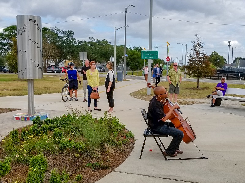
New Orleans’ Lafitte Greenway Linear Park runs through districts ravaged by Hurricane Katrina. Residents were consulted about their needs and preferences for this green area before the plan was implemented. Photo: Bart Everson
Beyond our borders, many linear parks have recently been designed and built throughout the world with significant social impact. Several of the more notable projects were developed in North America to recover land occupied by former railways, such as the spectacular New York High Line and its elevated layout, or to coexist with existing structures, as in Mexico City. Some have breathed new life into streets and avenues, and others have cleaned-up old industrial or port areas. This is the case of New York’s Riverside Park South, on the Hudson River.
The primary motivation behind the Lafitte Greenway linear park in New Orleans was the revitalisation of areas ravaged by Hurricane Katrina in 2005. This initiative brought new life to a five-kilometre long former railway site that runs through eight neighbourhoods in the historic centre. Residents were consulted about preferred uses and facilities for the green space, and particular attention was given to the cultural and historical identity of the area. The result has been a lively park that meets the citizens’ needs, encourages cycling and bustles with activity.
Other cities in the United States, such as Boston and its Big Dig, or Bellevue in Washington state with its future Grand Connection corridor, currently in the design process, have also proposed longitudinal parks in their urban centres.

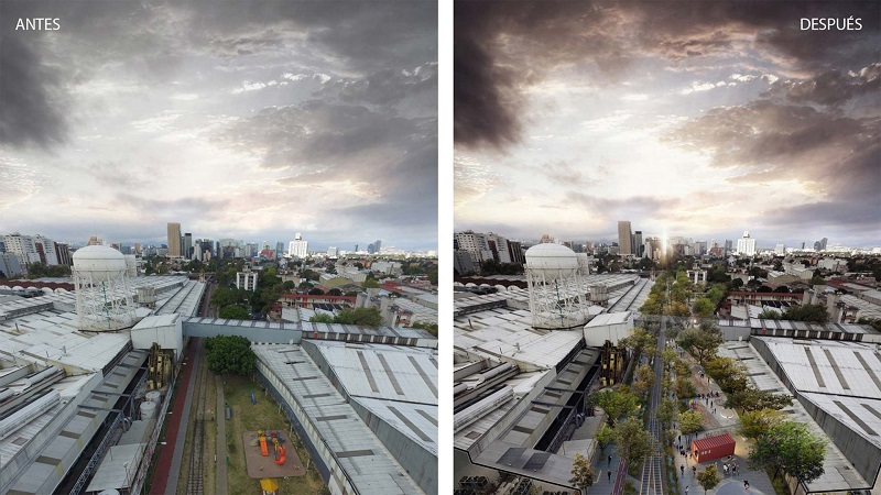
Area around the Modelo brewery in Mexico City before the Ferrocarril de Cuernavaca Linear Park, and final rendering. Image courtesy of Gaeta Springall Arquitectos.
One of the most notable longitudinal park projects, owing to its creative design and combination of practical and aesthetic elements, has recently been completed in the south of Mexico City. In 2016, the local government decided to breathe new life into a 4.5-kilometre strip that was formerly occupied by a historic rail freight line.
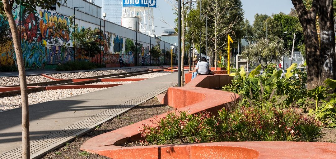
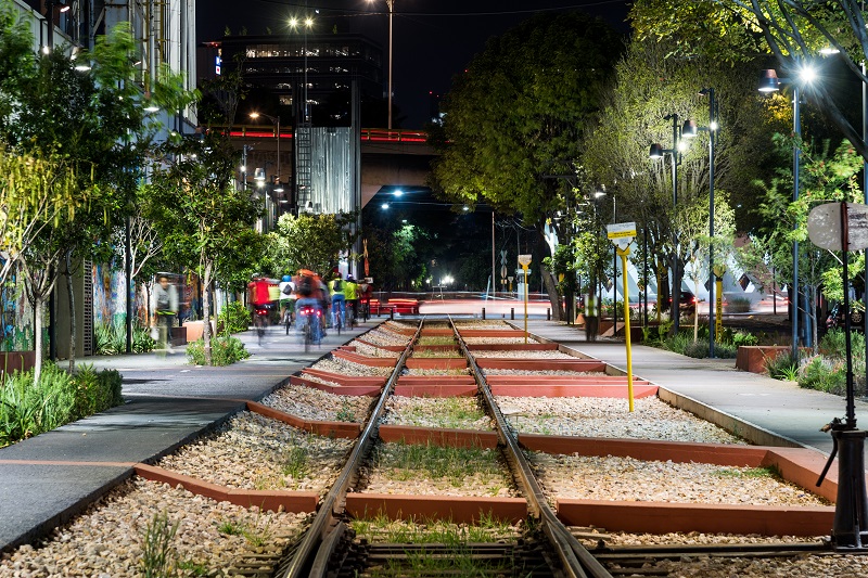
The so-called Ferrocarril de Cuernavaca Linear Park was structured around a simple and highly visible element: a continuous, zigzagging red line on the ground, which makes the park readily identifiable throughout its route. The line continually crosses the rail track to symbolise the “scab” that connects both sides, with benches and other urban furniture positioned throughout the park, including children’s playgrounds.
The project, designed by the Mexican studio Gaeta Springall Arquitectos, sought to build a community spirit across the 22 neighbourhoods through which it runs, with particular attention to the identity and historical memory of the site, and to encourage citizens to take ownership of the new spaces. The new park, envisaged as an urban forest, is part of a larger unit, the CDMX Green District, a network of public green spaces that spans the entire metropolitan area.
